Back in the Water Part II
Discussion around practice and preparation for diving and photogrammetry skills with depth maps being dropped as mesh source when insufficient coverage caused issues.


Discussion around practice and preparation for diving and photogrammetry skills with depth maps being dropped as mesh source when insufficient coverage caused issues.

Discussion examining the benefits of occlusion maps applied to Metashape models to improve level of visible detail with low poly count plus review of online hosting of massive detail models.

News from Deep3D including showcase videos, book publication, conference speaking and metashape training

A while back I nearly didn’t answer the phone. It was one of those international numbers and I didn’t recognise it but something told me to pick it up. I spent the next 30 minutes chatting to John Kinsella of Ocean Divers in Ireland all about 3D reconstruction and how it could be used in Read more about Wrecked in Second Life[…]

Short discussion on first dive after COVID-19 lockdown and using UWIS tracker for 3D reconstruction and improving local accuracy of model with adjustments to tracker unit location.
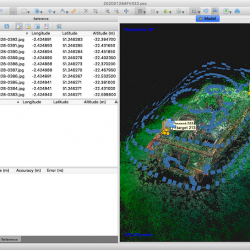
It should come as no surprise to find we like efficiency. Anything that makes life easier will always be welcomed with open arms and the UWIS navigation system does just that. Maintaining efficiency carries on above the waves. Every single image is traceable back to the project or subject and retrieval takes seconds. Its part Read more about You need an App for that[…]

Discussion on remote photogrammetry of a Lancaster bomber propeller during lockdown using masks to improve model quality

UWIS underwater GPS navigation continues apace with real-time viewing of 3D wreck models during a dive.

Discussion on UWIS navigation and Metashape photogrammetry using depth maps

Underwater GPS being used to reconstruct 3D photogrammetry models.