
For the previous 3 months we have been immersed in a partnership with Devon & Cornwall and Dorset police, working with their Forensic Collision Investigation officers – the people who record the evidence, analyse and report on the most serious road accidents.
The levels of accuracy, detail and repeatability to forensically preserve a crash scene in 3D are about as tough as it gets. The workflow to preserve evidence and methods and techniques capturing a car crash have been refined and improved to new levels, and can be applied to any 3D model. Which is why we have reprocessed the SS Gwladmena.
The Gwladmena Revisited
Sitting at a depth of 38m in Bressay Sound, Shetland, the Gwladmena was scanned back in 2016 and was to prove to be a wreck of many firsts; the first to be scanned over multiple dives, the first to be georeferenced from sonar data and the first large shipwreck to be scanned in its entirety.

The 2016 model was impressive in its time, but things have moved on. Workflow to produce a highly detailed and accurate model have been refined and hardware to process has moved on. It was time to take another look.
Source Images
We use Adobe Lightroom to manage every single image ever shot. The catalogue now holds 250k images…but thanks to management finding the 2036 images needed to reconstruct the Gwladmena was a breeze. The first step of reprocessing began with the new tools in LR…the source images for reconstruction were not the same as in 2016.
The main steps to build a 3D model remain the same; align, dense cloud, mesh & texture. Metashape has improved performance over the last 4 years and reduced the time taken for the steps, and the actual details of the workflow – refining the data – has changed too. This is where accuracy and detail are sharpened, and the lessons of police forensics applied.

Gwladmena Reborn
Reprocessing the latest version of the SS Gwladmena took less time than the original and has yielded far better results. More detail, more accuracy and verification of GIS data gives us more confidence in the final result:
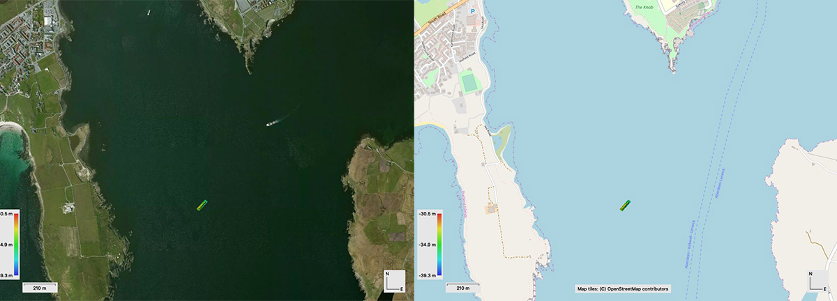
There is also a neat new tool available in the latest version of Metashape Pro. There is now an option to view the ortho photo or DEM in context of the rest of the planet – either as a satellite or map view. Most wrecks lie offshore and this view would not really be relevant, but the Gwladmena lies in Bressay Sound, Shetland, and as such is surrounded by land:
Improved Animation
A client was looking for some video content of a 3D model and the reprocessed Gwladmena was ideal material. Creating flyaround videos has been around since version 1.4 and has steadily improved since then and since the later versions of 1.5 we can now see the camera track:

And the resulting video can be seen here:
Conclusions
Archive research about the Gwladmena has revealed she suffered a few incidents before sinking. Not long after launching she ran around in the Thames, and a few years later sustained damage after breaking her moorings in Bilbao Harbour and colliding with other ships.
Just like the ship itself, data can live on and be reused as lessons are learned and applied. Photogrammetry is evolving and so are the methods and techniques – thanks in part to meeting police requirements – to digitally preserve what is on the seabed.
2 thoughts on “Old Data New View”
Comments are closed.